Valley Journal
Valley Journal

This Week’s e-Edition

Current Events

Latest Headlines

What's New?

Send us your news items.

NOTE: All submissions are subject to our Submission Guidelines.

Announcement Forms

Use these forms to send us announcements.

Birth Announcement
Obituary

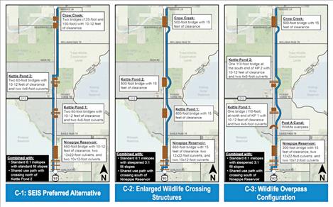
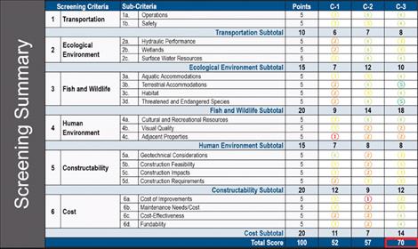
MDT shares draft proposal for highway improvements along Ninepipe corridor

Hey savvy news reader! Thanks for choosing local. You are now reading
1 of 3 free articles.


Subscribe now to stay in the know!

Already a subscriber? Login now

CHARLO — The Montana Department of Transportation (MDT), in collaboration with the Federal Highway Administration (FHWA) and Confederated Salish and Kootenai Tribes (CSKT) held informational meetings last week to share what may be the last draft of their feasibility findings for improving the Ninepipe corridor. This comes as part of an effort that MDT Project Manager Vicki Crnich says has been underway since 1996.  

The MDT study is intended to evaluate the viability of the project preferences identified in the Supplemental Environmental Impact Statement (SEIS) conducted alongside the FHWA and CSKT back in 2008 to address traffic and safety concerns. The Ninepipe segment of U.S. Highway 93 passes through federal and tribal lands designated for wildlife management, environmental protection and cultural preservation. Protection of these uses must be considered before any project is decided upon. 

According to the MDT website, the SEIS was re-evaluated in 2016 for the Ronan-Urban segment of the corridor to confirm proposed design changes and project segmentation/phasing. The Ninepipe segment was not addressed during the re-evaluation process. “Since completion of these previous efforts, MDT has proceeded to develop projects in stretches of U.S. Highway 93 adjacent to the Ninepipe segment and has encountered multiple challenges relating to constructability, impacts and costs,” the website states. “This feasibility study is being completed to proactively address these challenges by identifying potential constraints and considering viability before a project for the Ninepipe segment is nominated.” 

“From the public we heard quite a few comments about the desire to minimize impacts to adjacent properties, whether they be nearby businesses or residents … We had several folks mention they want to see that we make sure and coordinate with agencies and stakeholders, and we’ve done that in a number of ways,” Sarah Nicolai commented at the Jan. 12 virtual meeting. “We heard from folks asking us to consider how improvements would connect with other projects like Post Creek Hill and the Eagle Pass Trail that are upcoming in the corridor … We had several requests to make sure we consider the cultural and traditional elements of the landscape in coordination with the cultural committees and the tribal elders.”

The current feasibility study began by considering the preferred parameters outlined in the 2008 SEIS, before developing two additional options to improve transportation system performance and enhance wildlife accommodations with the goal of reducing resource impacts and wildlife-vehicle conflicts.   

An updated traffic analysis since the 2008 SEIS showed that 2020 traffic volumes ranged from approximately 7,000 vehicles per day (vpd) south of Montana Highway 212 to just over 8,500 vpd to the north. Summer traffic was found to be approximately 35% higher. According to the study, “passing demand is high but passing capacity approaches zero, so drivers will spend a lot of time following slower vehicles,” results similar to what was found in the SEIS traffic analysis. The crash rate for the Ninepipe corridor was also found to be higher since the SEIS, 4.3 crashes per mile per year versus 2.8 in the 2008 SEIS, though with a lower severity rate and percent of fatalities. The most common crash type was found to be with wild animals. 

The study also found that a large number of deer, birds and turtles are struck within the Ninepipe segment of U.S. Highway 93, and since the 2008 SEIS, data shows the grizzly bear population is expanding with 45 highway crossings by nine different bears documented in the Ninepipe vicinity from 2007 to 2019. Additionally, the study found grizzly bear mortalities from car collisions has notably accelerated in recent years with 61 vehicle-caused grizzly bear mortalities in the vicinity from 2004 to 2019.  

Key features of the original 2008 SEIS project preferences (Option C-1) include two bridges of 120 and 150 feet at Crow Creek with 10-12 feet of vertical clearance, two 60-foot bridges with 10-12 feet of clearance and two culverts at the two Kettle Pond locations and a 660-foot bridge with multiple culverts and 10-12 feet of clearance at Ninepipe Reservoir. There would also be a shared use path crossing north of Kettle Pond. 

Options C-2 and C-3, created according to increased knowledge from the current feasibility study, take a slightly different approach. C-2 focused on enlarged wildlife crossing structures to accommodate the size of the large mammals expected to cross in the area, including two 800-foot bridges by Kettle Pond, a 500-foot bridge at Crow Creek, a 660-foot bridge with multiple culverts to channel water at Ninepipe Reservoir and a shared use path crossing south of Ninepipe Reservoir, with all bridges to include 15 feet of vertical clearance. Option C-3 went further, including a specific wildlife overpass, along with two 110-foot bridges with culverts and 10-12 feet of vertical clearance at Kettle Pond, a 500-foot bridge at Crow Creek, and a 300-foot bridge at Ninepipe Reservoir with culverts and a shared use path. All three options carry a two-lane configuration.

According to a statement by MDT, all options were evaluated numerically according to their performance under screening criteria, including transportation, ecological environment, fish and wildlife, human environment, constructability, and cost categories. While the study determined all three options would be feasible to implement and stated there are no known conditions that would prohibit construction of any option given adequate funding, Option C-3 was determined to be the least impactful with more benefits and lower cost, and thus was found to be the preferred option to advance for future project development. 

The study is expected to be finalized by the end of February. Should any projects advance from this study, Consultant Project Manager Scott Randall explained the next steps would include funding identification, project nomination, project development, including environmental documentation and collaboration with resource agencies, stakeholders and the public. No funding has been identified for corridor projects at this time, however grants may become available. 

“Part of the reason behind doing this feasibility study is because it has been 14 years and by dusting things off and looking at the things that have changed, it sets us up to be maybe more competitive to go after grants,” Crnich explained in the Jan. 12 meeting. 

A recording of the virtual meeting can be seen at: mdt.mt.gov/pubinvolve/US93Ninepipe. The current draft of the study can be viewed online at: https://www.mdt.mt.gov/pubinvolve/US93Ninepipe/docs/US93Ninepipe-FeasibilityStudy-2023-01-04.pdf. Comments about the study can be submitted throughout the review period until Feb. 6 online at: www.mdt.mt.gov/mdt/comment_form.shtml. Please note comments are for the U.S. Highway 93 Ninepipe Corridor Feasibility Study. 

Sponsored by: