CSKT land use planner shares concerns over density map repeal
Keep Reading!
You’ve reached the limit of 3 free articles - but don’t let that stop you.
 CSKT Tribal Council candidates speak on issues at forum
FLATHEAD RESERVATION — Members of the Confederated Salish and Kootenai Tribes of the Flathead Reservation will go to the polls Saturday, Dec. 13, to elect councilmembers to represent four districts and one at-larg...
 Legislative Notes
 Over the past 40 years, Montana’s property tax burden quietly shifted from natural resource extraction and industries to homeowners. From 2003 to 2023 alone, residential property as a percentage of the total taxab...
POLSON — Ashley Whitmore, 33, will face a jury trial on March 9 in Lake County District Court on one charge of deliberate homicide in the shooting death of 39-year-old Adam Mowatt of Polson. She was arraigned Nov. 20 in Lake County District Court before the Honorable John Mercer, where she...
 Cherry growers narrowly dodge labor shortage as Trump policies worry workers
LAKE COUNTY — In early July, a transformation takes place on the eastern shorelines of Flathead Lake. As the Mission Mountains loom in the background, endless groves of trees begin to display little red frui...
Send us your news items.
Use these forms to send us announcements.
Birth Announcement
courtesy photo
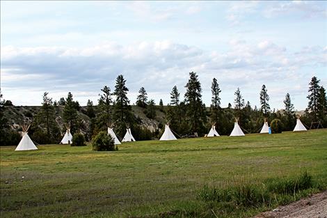
CSKT land use planning seeks to preserve sensitive land areas and doesn’t allow for subdivisions along the Flathead River corridor or in buffer zones adjacent to tribal wilderness unless they are in an existing clustered site. Pictured above is a river honoring encampment along the Flathead River.
Issue Date: 2/7/2018
Last Updated: 2/6/2018 5:31:42 PM |
By
Caleb M. Soptelean
You’ve reached the limit of 3 free articles - but don’t let that stop you.
Sponsored by:
© Copyright Valley Journal, Ronan, MT. All rights reserved. | Privacy Policy
| Terms of Use | Submission Guidelines
Weather data provided by 
